Maps hold power. For millennia, the borders and place names represented on world maps signify who claims or possesses control of a geographic region. Through colonization, violent conquest or territorial acquisition, the history and sovereignty of long-established empires are erased when removed from the world map.
Today, it can feel as though the world map is set in stone. After all, the United Nations hasn’t recognized a new, sovereign nation since 2011, when South Sudan broke away from Sudan. But beneath the surface of our standard world map lies the omission of thousands of territorial claims by Indigenous peoples.
Enter native-land.ca, an online mapping project created by Native Land Digital (NLD), a Canadian non-profit organization established in 2018. The project honors the history of Indigenous groups around the world by acknowledging their territorial claims in colonized nations.
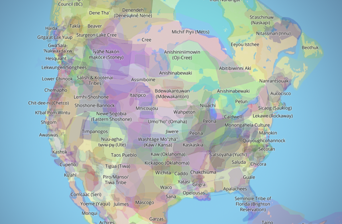
The mapping project is formatted as an interactive digital globe, with the territorial boundaries of Indigenous tribes highlighted in various colors. Many of the territories overlap, highlighting the complex history and diversity of Indigenous peoples around the world.
“We strive to go beyond old ways of talking about Indigenous people and to develop a platform where Indigenous communities can represent themselves and their histories on their own terms,” NLD’s mission statement reads. “In doing so, Native Land Digital creates spaces where non-Indigenous people can be invited and challenged to learn more about the lands they inhabit, the history of those lands, and how to actively be part of a better future going forward together.”
NLD’s team is made of a majority of Indigenous staff members, with executive leadership hailing from Māori, Saraguro, Payómkawichum, Métis and Anishinaabekwe ancestry, to name a few.
According to NLD’s founder, Victor Temprano, the site wasn’t made as a reference map for Indigenous groups, as they likely already know their own tribe’s territory. “A lot of settlers are not really aware of the situation with the land, and a lot of people are vaguely interested in it, but there aren’t many resources to explore it. I’m really happy to see that it’s becoming useful to Indigenous Peoples themselves,” Temprano said to CBC News in 2018.
NLD describes the mapping project as a “living document,” receiving its information from Indigenous knowledge holders. Given the complexities of such a large project, NLD acknowledges there may be inaccuracies on the map: “We respect the rights of Indigenous data sovereignty, and we are committed to an ongoing process of collaboration, growth, and learning,” the project’s online preface reads. “We work to update and replace information that is a continuation of trauma caused by theft, injustice, misinformation, and ignorance.”
In addition to viewing the territories of Indigenous tribes around the globe, users have the option to view the approximate geographic locations of various Indigenous languages. Users can also view the locations of territorial treaties, including the cessions that forcibly displaced millions of Indigenous people in the U.S.
By default, non-Indigenous place names, borders and roadways are hidden from the native-land.ca map. If a user wants to view their hometown on the map, they have the option to search for their ZIP Code or address.
According to the native-land.ca map, the University of Massachusetts Amherst campus sits on the lands of the Nonotuck, Pocumtuc and Nipmuc tribes.
Nathan Legare can be reached at [email protected] and followed on X (formerly Twitter) @Legare_Nathan.


